In this tutorial you will learn:
- Common geospatial vector datasets formats
- An introduction to sample data from Forest Watcher, a field monitoring application
- How to upload a vector dataset to a free public ArcGIS Online (AGOL) account
- How to upload a vector dataset to an organizational AGOL account
To start this tutorial, you need:
- An ArcGIS Online (AGOL) account (Public or Organizational). Read more about the different AGOL plans here.
Common geospatial vector dataset formats
Vector datasets are composed of points and line segments. When used in geospatial software (like MapBuilder!) they typically represent discrete objects or locations such as individual trees or country boundaries. Vector datasets come in many formats but there are some common types that you will regularly see:
- shapefile (.shp): Developed by ESRI, this is the most common geospatial vector format. Each shapefile contains multiple files and therefore you will often see it shared as a compressed .zip file.
- GeoJSON (.geojson): This open format is based on the JavaScript Object Notation (JSON) specification and contains a set of key-value pairs.
- Comma Separated Value (.csv): Although this open text format is typically used for non-geospatial data, it is also commonly used to represent geospatial data in a structured way if it contains location data such as latitude and longitude values.
All three of these formats can be used in ArcGIS Online, which is the platform that powers MapBuilder. In this tutorial, we will look at an example of uploading a GeoJSON file from the Forest Watcher application.
Sample data from the Forest Watcher application
Forest Watcher is a free tool from Global Forest Watch (GFW) that allows users to monitor areas of interest, view deforestation and fire alerts, navigate to a location in the field to investigate and collect information in custom reports. Find out more about Forest Watcher here.
Download a small GeoJSON file linked below of sample Forest Watcher reports. Remember where you save the file because you will be adding to your web map shortly.
How to upload a vector dataset to a free public AGOL account
1. Download our sample data
If you have not done so already, review the section "Sample data from the Forest Watcher application" above to download our sample data.
2. Navigate to Map Viewer Classic
With a free public AGOL account, you will upload your vector dataset to a web map via the Map Viewer interface. Keep in mind that you will not be able to access this data from another web map. Therefore, the web map you use to upload your data will need to be the same web map that you use in your MapBuilder application.
If you already have a web map that you intend to use in your MapBuilder application, open it and proceed to the next step. If you do not have a web map or if you do not know how to create a web map, follow the instructions in this tutorial before proceeding to the next step.
3. Upload the GeoJSON file via Map Viewer
With a free public AGOL account, users can upload and host a limited amount of vector data (up to 2GB) on ArcGIS Online.
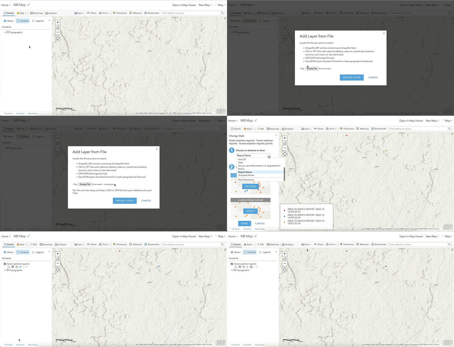
- Make sure that your web map is open in Map Viewer Classic.
- Click the Add button in the top toolbar.
- Click the Add Layer from File button from the menu.
- Click the Choose File button.
- Choose the GeoJSON file you downloaded in the first step.
- Click the Import Layer button.
- Optionally, adjust the layer settings in the left panel. For example, you can change the layer title or the styling. If you're interested in learning more about the adjusting options, go to our Resources page.
4. Save your map
- Click the Save button in the top toolbar.
- Click the Save button from the menu to save your web map.
5. Use your dataset in a MapBuilder application
Your vector dataset is now saved in your web map and can be viewed in your MapBuilder application. Review this tutorial if you are unfamiliar with how a web map is used to power your MapBuilder application.
How to upload a vector dataset to an organizational AGOL account
1. Download our sample data
If you have not done so already, review the section "Sample data from the Forest Watcher application" above to download our sample data.
2. Navigate to the Content page
With an organizational AGOL account, you will upload your vector dataset as an item, which will allow you to update it in the future and reference it in multiple places, such as a web map or in your MapBuilder Configuration File.
- Navigate to ArcGIS Online and log in.
- Make sure to sign in so that you can save your dataset.
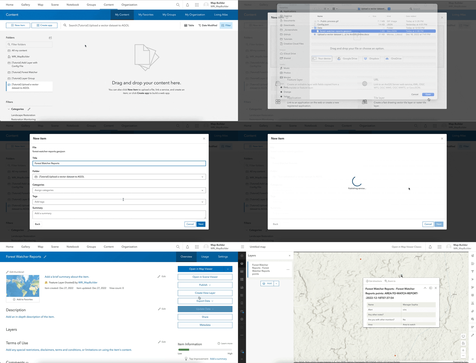
- Click Content on the top menu.
- If the My Content tab is not selected in the secondary top menu, click the My Content button.
3. Add the GeoJSON file as a new item
With an organization AGOL account, users can upload and host vector data on ArcGIS Online. Keep in mind that that hosting vector data in ArcGIS Online will cost credits.
- Click the New item button.
- Click the Your device button.
- Choose the GeoJSON file you downloaded in the first step.
- Select “Add forest-watcher-reports.geojson and create a hosted feature layer”.
- Click the Next button.
- Rename the dataset in the Title field.
- Optionally, select a specific location in the Folders This will allow you to store your dataset in a specific location and keep your items organized.
- Click the Next button. AGOL should begin uploading your dataset.
- When the upload is complete, the Map Viewer should load and show the dataset on a web map.
4. Use your dataset in a MapBuilder application
Your vector dataset is now saved in your AGOL account as a hosted feature layer and can be used in your MapBuilder application. There are two approaches to adding a hosted feature layer to a MapBuilder application:
If you need additional assistance, please do not hesitate to contact us.


